Któż z nas nie wie kto to geodeta. Jeśli deweloper nie wie, znaczy że nie jest developerem.
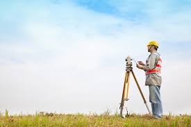
Geodeta jest nazwą zawodu. Dotyczy osoby zajmującej się geodezją. Geodezja jest nauką dotyczącą 1. Ustalania wielkości i kształtu Ziemi oraz 2. Określaniem położenia punktów na jej powierzchni. Efektem jest geodezyjny pomiar terenowy i pojedyncza praca kameralna. Efektem jest różnego typu opracowanie graficzne jak na przykład mapa czy profil. Również dokument tekstowy o charakterze prawnym (na przykład podczas rozgraniczenia nieruchomości).
Przed II wojną światową zawód geodety oznaczał osoby zajmujące się geodezją jako dyscypliną naukową (była to stricte dziedzina wiedzy). Natomiast osoba w terenie, zajmująca się miernictwem, wykonująca prace geodezyjne związane z pomiarami małych powierzchni (geodezja niższa), był to mierniczy przysięgły i był osobą wykonującą zawód publicznego zaufania. Taki podział należał do tradycji polskiej, ale uległ zmianie z powodów politycznych po 1945 roku.
Aby geodeta mógł wykonywać samodzielne funkcje w dziedzinie geodezji i kartografii, niezbędne jest posiadanie uprawnień zawodowych, zdobywanych w trakcie studiów kierunkowych
 Któż z nas nie wie kto to geodeta. Jeśli deweloper nie wie, znaczy że nie jest developerem.


